In a Land Court case in which the plaintiffs sought declaratory and injunctive relief for the defendants' interference with the plaintiffs' easement to use a beach on the defendants' property, the judge correctly determined that the relocation of the mean high water line by the defendants' predecessors' filling of the tidelands did not move the littoral boundary unambiguously described in the easement and that the plaintiffs were entitled to use of the beach forward from that line over the artificially created land. [592-594]
CIVIL ACTION commenced in the Land Court Department on June 18, 1992.
The case was heard by Robert V. Cauchon, J.
Eric W. Wodlinger for the defendants.
Herbert J. Bober & Peter S. Farber for the plaintiffs.
JACOBS, J. Claiming that a fence erected by the defendants interfered with their long-established easement to a beach along the easterly side of the defendants' lot in Chatham, the plaintiffs sought declaratory and injunctive relief in the Land Court in 1992. The plaintiffs contend that the fence hugs the shoreline and confines their use to a narrow corridor at the water's edge. The judge, following a trial and a view, declared that the upland line of the easement, originally described as "a line parallel
Page 591
with and five feet back from the mean high water line," was not relocated when the mean high water line moved eastward along an expanded beach created as a result of the placement of fill to seaward of the defendants' lot. [Note 5] The filling had been done by the parties' common predecessors in title, Frederick W. and Helen E. Crowell (the Crowells) after they had granted the easement. The defendants essentially contend [Note 6] that the easement, originally located near their home, followed the changed shoreline and did not remain fixed as determined by the judge. We affirm.
The defendants are the owners of Lot 25 in the Eastward Point subdivision in Chatham, which was created in 1957 by the Crowells. The easement was granted by the Crowells between 1959 and 1963 when they owned Lot 25 and was included in various conveyances of subdivision lots to the plaintiffs or their predecessors in title during that period. [Note 7] The relevant easement language is:
"Also the [lot] is conveyed together with the right to use the beach along the Easterly side of Lot 25 back to a line parallel with and five feet back from the mean high water line, in common with all others who are or who may become entitled to use the same, for bathing and sun bathing and to pass and repass thereon, and access to said bathing beach will be over . . . Lot 24."
The judge found, as stipulated by the parties, that "between 1962 and 1964, [Frederick] Crowell directed the excavation and
Page 592
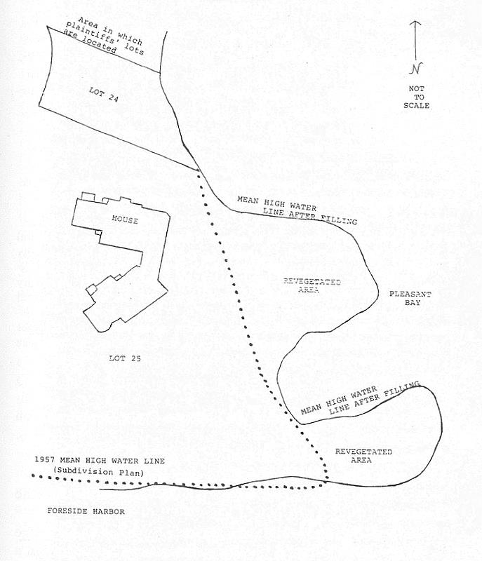
dredging of soil and other fill from the cove adjacent to Lot 25, which . . . was then deposited along the easterly line of Lot 25." He also found that "the [f]ill created two lobes [of land], changing the actual location of the mean high water and shorelines of Lot 25." The drawing in the Appendix shows the new lobes of land, designated as revegetated areas, the relevant water lines, and the defendants' home.
"The extent of an easement depends on the circumstances of its creation.... When created by conveyance, the grant ... must be construed with reference to all its terms and the then existing conditions so far as they are illuminating.' J.S. Lang Eng': v. Wilkins Potter Press, 246 Mass. 529, 532 (1923). Hewitt v. Perry, 309 Mass. 100, 105 (1941)." Mugar v. Massachusetts Bay Transp. Authy., 28 Mass. App. Ct. 443, 444 (1990). The language of the easement in question has not been changed from the time of the original grants, and is not ambiguous. We agree with the judge that whatever Crowell's intent may have been in depositing the fill, he could not thereby alter the location of the easement.
There is well-settled authority for the proposition that littoral (shoreline) boundaries are not fixed, because natural processes of accretion or erosion change them, and that easements, stated to run with such a boundary, ordinarily will follow the naturally changing line. See Phillips v. Rhodes, 7 Met. 322, 325 (1843). The judge, however, correctly concluded that "accretion by steam shovel' is not a recognized method of changing littoral boundaries." Unlike cases resolving issues of ownership of artificially created land with littoral boundaries, [Note 8] we have found no case, nor has one been cited to us, which relates to the effect on an easement described by a littoral boundary where that boundary has been relocated by artificial means. In the absence of such authority, we conclude that the plaintiffs' easement was
Page 593
not relocated as a result of conditions created by the filling done by the owners of the servient estate.
The judge correctly determined that the "mean high water line" prior to filling defines the easement. For the reasons stated in the margin, his selection of the mean high water line existing in 1957 as the controlling line was not mistaken. [Note 9] See Krueger v. Devine, 18 Mass. App. Ct. 397, 398-399 (1984).
The defendants assert that the decision below results in a "virtually land-locked" easement. That contention ignores that the plaintiffs were granted access to the entire formerly existing "beach" along the line of mean high water. After filling, that right must extend to all the new beach because no express limitation to seaward was placed on the easement before the filling. A beach, however delineated, by usage and decision, comprises land that provides "access to the water for bathing or for sun baths." Anderson v. DeVries, 326 Mass. 127, 134 (1950). "When an easement . . . is created, every right necessary for its enjoyment is included by implication." Sullivan v. Donohoe, 287 Mass. 265, 267 (1934).
While the placement of fill in the formerly flowed tidelands
Page 594
created a new area over which the tide flows, [Note 10] that fill only served to expand the beach area available to the plaintiffs because, in the plain wording of the easement, their right of use for "bathing and sun bathing and to pass and repass thereon" was granted "back" to a fixed upland line. The meaning of the term "beach" is to be interpreted in the light of the relevant circumstances, and of the instruments creating the easement. See Myers v. Salin, 13 Mass. App. Ct. 127, 142 (1982), and cases cited. There was no error.
Judgment affirmed.
Page 595
APPENDIX
FOOTNOTES
[Note 1] Of the Bergh Realty Trust.
[Note 2] Clare L. Bergh, trustee of the Bergh Realty Trust; Charles V. and Louise L. Reydel; and Donald L. and Susan G. Boudreau.
[Note 3] Of the Goodrich Chatham Realty Trust.
[Note 4] John J. Coleman, trustee of the Goodrich Chatham Realty Trust.
[Note 5] The Land Court judgment also orders the defendants to remove any and all fencing which inhibits the plaintiffs, access to the easement. The Land court judge found that the defendants, in 1992, "installed a snow fence and [plantings] such as rosa rugosa and spartina patens to combat erosion and similar damage from storms, flooding, and abnormally high tides." Because the judge found that the plantings do not interfere with the plaintiffs' rights, the Land Court judgment includes an order allowing the defendants to maintain the plantings.
[Note 6] The parties have invoked estoppel arguments in their briefs which do not appear in the trial record, and were not referred to by the Land Court judge. Accordingly, we do not consider them. Mass.R.A.R 16(a)(4), as amended, 367 Mass. 921 (1975).
[Note 7] There is no dispute that the easement is valid or that its language properly is recited in each of the conveyances to the parties. Once fixed, such easements pass by deed according to G. L c. 183, s. 15. see Labounty v. Vickers, 352 Mass. 337, 346 (1967).
[Note 8] See, e.g., Michaelson v. Silver Beach Improvement Assn., 342 Mass. 251, 254 (1961) (in discussing accretions that change lines of ownership, the court stated: "Such accumulations need not be due entirely to natural causes, provided they are not caused by the littoral owner himself"); Adams v. Frothingham, 3 Mass. 352, 362 (1807) ("Whatever increase, therefore, happened from natural causes, or from a union of natural and artificial causes, within [the 'flats'], must be to the benefit of the owner of the upland.... This increase is of necessity gradual and imperceptible"). See also County of St. Clair v. Lovingston, 90 U.S. (23 Wall.) 46, 68-69 (1874) (whether the increases were affected by artificial means is immaterial, so long as they proximately were caused by the flow of water and occurred imperceptibly over time).
[Note 9] The parties agree that the judge's express reference to a Land Court plan, which does not specifically identify the mean high water line of 1957, implicitly refers to a subdivision plan. The parties stipulated that this original, recorded subdivision plan shows a mean high water line in 1957. At trial, a plan submitted as a basis for registration of some of the subdivision lots, and approved by the Chatham Planning Board, including the lot of the defendants and lots of two of the plaintiffs, was introduced as an exhibit. This plan also shows the 1957 mean high water line. The parties do not indicate there are any differences between this plan and the original subdivision plan, and essentially agree that the Land Court plan cited by the judge was prepared with reference to the latter plan. Conveyances of lots of unregistered land, such as the lot of one of the plaintiffs, were made by reference to the original subdivision plan, and those of registered land by reference to the Land Court plan. "A plan referred to in a deed becomes a part of the contract so far as may be necessary to . . . determine the rights intended to be conveyed." Wellwood v. Havrah Mishna Anshi Sphard Cemetery Corp., 254 Mass. 350, 354 (1926). Given the clear identification of the mean high water line of 1957 in this record, the judge did not err in relying on that line as closer in time to the establishment of the easements than any other identified line, and one which best reflects the then natural situation. See McCarthy v. Oak Bluffs, 419 Mass. 227 (1994) (a pre-fill water line properly was relied upon to determine ownership along an artificially altered shoreline). Moreover, the judge's reliance on the 1957 mean high water line in the subdivision plan is supported by the location of that line in a trial exhibit prepared by an expert for the defendants.
[Note 10] The Land Court judge noted in his decision that the filling by the Crowells had not proceeded under a G. L. c. 91 license and therefore was illegal. After oral argument the defendants presented evidence that they had received a license under the so-called amnesty provisions of 310 Code Mass. Regs. s. 9.28 (1996). The effect of such a license, or lack of it, did not enter into the Land Court's decision, nor is such a consideration necessary to our decision. For a discussion of licensing under c. 91 applicable to tidelands, see Pike & Vaughan, Massachusetts Tidelands Laws and Regulations, 77 Mass. L. Rev. 98 (1992). Also, we agree with the judge's observation that the issue of relative rights in the filled land was not raised and therefore need not be addressed. Compare Hewitt v. Perry, 309 Mass. 100, 104-105 (1941).