On March 9, 1979 Ruth F. Nathans and her daughters, Phyllis E. and Judith I. Nathans, filed with this Court a petition to have their land on Arrow Street in the City of Cambridge and County of Middlesex brought under the operation and provisions of Chapter 185 of the General Laws and to have their title therein registered and confirmed. An answer was filed by respondents Edward R. Levine and Edith M. Levine claiming to own a portion of the land described in the petition. The answer alleges that "the Land Court has previously established boundaries on a parcel of property that adjoins the property out of which Plaintiff's property is part. The boundaries are inconsistent with the boundaries which Plaintiff seeks to establish by this petition to register." An answer also was filed on behalf of Carol R. Johnson whose property abuts locus in the rear, but the objections on behalf of this respondent were disposed of by a stipulation relative to the fire escape which overhangs and encroaches upon a portion of the Johnson property. Accordingly, the sole issue remaining in the case is the establishment of the northwesterly line of the property, commonly known as 1134 Massachusetts Avenue.
A trial was held at the Land Court on May 7, 16 and 20, 1980, and a view was taken in the presence of counsel on May 29, 1980. At the trial a stenographer was appointed to record the testimony. All exhibits introduced in evidence are incorporated herein for the purpose of any appeal. At the trial the testimony fell into two categories. There were three expert witnesses who are surveyors and who were familiar with the situation on the ground. Each of them testified as to the steps which he had taken to establish the disputed line and described what he had found on the ground and in the records at the Registry of Deeds and Cambridge City Hall which led to his conclusion. The other aspect of the case concerned the use of the buildings on the Nathans and Levine properties and the determination of the boundary by adverse possession by the parties and their predecessors.
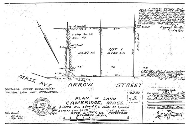
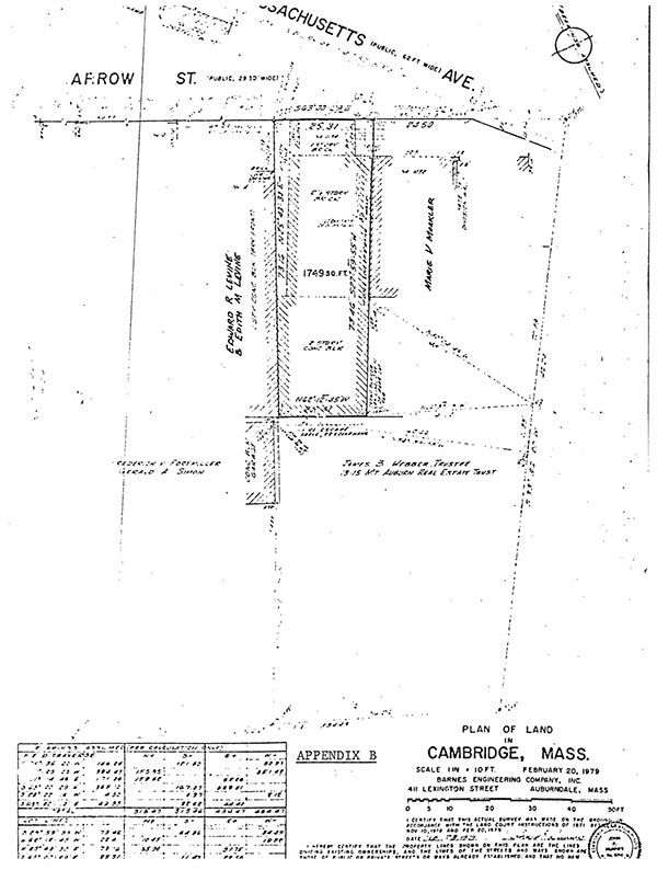
The dispute centers on the correct placement of the northwesterly corner of the petitioners' property at Arrow Street. It was triggered by the exhibition by Mr. Levine to Mrs. Ruth Nathans in October of 1978 of a plan which Mr. Levine had commissioned to be prepared at an earlier time and had filed for record prior to the confrontation between the parties. This plan, a copy of which is attached hereto as Appendix A, is entitled "Plan of Land Cambridge, Mass. Owned by: - Edward E. and Edith M. Levine," is dated October 27, 1976 by Fred R. Joyce Company and was filed for record as Plan No. 1213 of 1976 on October 28, 1976. The plan was prepared by Eugene J. Mulligan and his son Eugene J. Mulligan, Jr., the latter of whom testified at the trial. There is no disagreement with the southwesterly corner of the locus as shown on the Mulligan plan which is similarly shown on the filed plan in this case (Exhibit No. 1) entitled "Plan of Land in Cambridge, Mass." dated February 20, 1979 by Barnes Engineering Company, Inc. (Appendix B). The Mulligan plan, however, shows the northwesterly corner of locus to be 2.57 feet southeasterly of where it appears on the filed plan. It does not itself give the latter figure which has been taken by the Court from the filed plan, but it runs the boundary line between the property of the petitioners and the respondents through the open space between the buildings on the properties and at the rear through the petitioners' building itself. The filed plan, on the other hand, uses the southeasterly face of the building on the rspondents' land extended to Arrow Street as the common boundary line. The difference may stem from the difference in procedure used by the two surveyors. The survey prepared for the respondent was based on the filed plan in Land Court Case No. 3900 entitled "Plan of Premises in Cambridge Belonging to W. H. Wentworth" and dated 1912 (Exhibit No. 7) which shows a drill hole in the curb on Massachusetts Avenue and one in the rear on the opposite side of Mount Auburn Street. These monuments, however, do not appear on the decree plan in said Case No. 3900. The Mulligans then proceeded to survey from the drill hole to locus by using distances set forth in deeds of record without reference to occupation on the ground. Emphasis was placed by them on the angle at the intersection of Arrow Street and Massachusetts Avenue which was computed differently by the three surveyors, the variation in computation depending in part on a difference in the city records used by them. The survey which was prepared for the petitioners made no use of the previous Land Court case since the surveyors
were unable to locate any monuments shown on the decree plan. Rather the survey commenced at the partition wall between the premises at 1132 Massachusetts Avenue and the locus at 1134 Massachusetts Avenue and proceeded around the property in a counterclockwise direction.
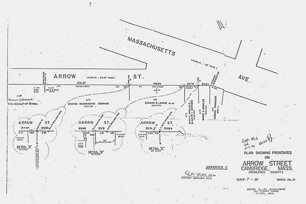
The apex of the dispute between the surveyors for the petitioners and respondents being the correct location of the common boundary line, the petitioners engaged a third surveyor to attempt to prove the boundary which they claim. The third expert witness was Gunther Greulich of Boston Survey Consultants whose work is denominated on Exhibit No. 6 entitled "Plan Showing Frontages on Arrow Street Cambridge, Mass. (Middlesex County)" dated March 26, 1980 (Appendix C). While no deeds to the property of the respondents were introduced, it was agreed that they held title to two parcels of land with approximately 100 feet of frontage on Arrow Street. The work by Mr. Greulich commenced at the corner of property of the Roman Catholic Archbishop of Boston and Boston Bookbinding Company, and he then proceeded in a southeasterly direction down Arrow Street
approximately 154.97 feet to a point where an iron rod was unearthed beneath the surface which Mr. Greulich testified in his opinion marked the boundary between land of Boston Bookbinding Company and the Levines. From the iron rod to the northwesterly corner of locus as shown on the filed plan was found to be 99.84 feet which is consistent with the 100 feet, more or less, of frontage as given in the Levine deeds. The frontage of Boston Bookbinding Company as surveyed by Mr. Greulich varies slightly from that set forth in its deed where it is stated to be 155.58 feet (as against the survey distance of 154.97 feet). The Mulligans had set a nail at the point where they found the Levine property to meet the abutter on the northwest. Boston Survey Consultants fixed this nail as being 2.34 feet southwesterly of the iron rod which they had located as marking the proper corner. Mr. Granton Dowse, who manages the building at 10 Arrow Street, the so-called Boston Bookbinding Company property, testified that he had requested permission from Mr. Levine to enter on the Levine property in order to sandblast the southeasterly face of the building. He explained that the Levine fence comes to the face of the wall of the building. Permission was denied by Mr. Levine. If in fact the Boston Bookbinding Company building is on the property line, the northwesterly corner of locus at land of respondents Levine as established by Mulligan would give the Levines more frontage than the records entitle them to have, not on the basis of the Mulligan survey but on the basis of Mr. Levine's claim to Mr. Dowse. Indeed if the Mulligan approach were used, each owner at least from the intersection of Massachusetts Avenue to Boston Bookbinding Company would have frontage inconsistent with the signs of occupation on the ground. It is persuasive that Mr. Dowse had a survey made of the 10 Arrow Street building when the building was renovated and that he did not dispute Mr. Levine's refusal to allow his workmen to enter between the properties in order to sandblast the wall facing the Levine locus. The only conclusion which can be drawn from the testimony is that Mr. Levine has been attempting to have his cake and to eat it too. The expert testimony in my opinion establishes that the filed plan correctly locates the disputed line.
The parties made no argument based on deeds in the chain of title. However, it is apparent from the abstract there is a discrepancy between the frontage given in a deed dated May 1, 1873 and recorded in Book 1259, Page 363, whereby James M. Robbins conveyed to Frank E. Carter the locus and gave the frontage on Arrow Street as being 23 feet 6 inches and that given on a 1935 plan (Exhibit No. 2) which shows the three row houses at the intersection of Massachusetts Avenue and Arrow Street of which the locus is one. This plan gives a distance of 25.37 feet as the frontage for the property now of the petitioners and shows the southeasterly face of the respondents' building as the property line. There is no explanation for the difference in the records which arose between 1873 and 1935. It is apparent, however, that at least since 1935 when the plan was prepared, the predecessors in title of the petitioners have claimed the boundary to be as shown on the filed plan. There was testimony that a one story (and basement) storage area was built at the rear of the original building at 1134 Massachusetts Avenue about 1935 or 1936 by Mrs. Mary Nathans, mother-in-law of Ruth and grandmother of the other two petitioners. The storage area was entered by a door into the ell at the end of what the parties describe as an alley or passageway but which in fact is the space between the buildings of the petitioners and the respondents Levine. At the same time the front of the house was made into a store. The senior Nathans conducted a used furniture business therein, rented the furniture to Harvard students and used the area in the rear for storage. Subsequently, in 1960, a second story was built over the former storage area by Ruth Nathans, and a room was added to Ruth Nathans' apartment. An entrance to the building was made in its northwesterly wall and the former door at the end of the alley converted to a window. The area in question was surfaced, and steps leading down were installed. Variances have been granted over the years so that five apartments and a store are now authorized. In a deed dated December 10, 1958 and recorded in Book 9319, Page 217, Mary Nathans conveyed the locus to her son David A. Nathans and Ruth F. Nathans, husband and wife as tenants by the entirety. Mr. Nathans died suddenly on April 27, 1960, and the petitioner Ruth Nathans, as the surviving tenant by the entirety, became the sole owner. She thereafter by deed dated February 25, 1975 and recorded in Book 12762, Page 264, conveyed the property to herself and her daughters as joint tenants, and the title so stands at the present time. The ownership by the Nathans family thus has continued for about forty-five years.
About eight years ago Mrs. Nathans found that the problems of an urban society were spreading to her "alley" and discussed the situation with Mr. and Mrs. Levine. Mr. Levine suggested that a gate be constructed across the alley affording access to the Nathans property and gave Mrs. Nathans permission to attach the gate to his building. Some years later, in 1978, a dispute arose about a key to the gate, and as detailed above this triggered the controversy now before the Court.
Little use has been made of the area by the Levines. They have claimed no easements in the area as an alternative to their claim to approximately 2.57 feet of the fee. Admittedly there has been a pipe running in a southwesterly direction along the wall of their building which formerly conducted oil thereto. The premises are not presently heated by oil as the tenant has installed a gas heating system, and the pipe presently is not used. However, the right to maintain it does not appear to have been abandoned. Mr. Levine also testified that his painters had stored ladders in the alley; this testimony is disputed, and in any event it seems to have been a one time only occurrence. The Levine roof can be reached without entering the vacant area, and a wall on the Levine property facing the Nathans house has no windows and is of nonwood construction so access to it would not seem to be required in any event. I find no credible evidence that the Levines ever used the area other than for the oil inlet. There was testimony that a predecessor in title of the Levines had two gasoline pumps located somewhere in the vicinity from which he serviced the members of the public and his own customers. It appears that at one time there was a swing arm attached to a pole, the base of which remains, which enabled fuel pumps of cars to be filled from the street from the gas hose which was attached to the swing arm. This avoided the necessity of cars coming onto the sidewalk. Several witnesses testified as to the presence of the pumps which undoubtedly must have been near the disputed area, but whether they were in front of the vacant space between the two buildings, in the "alley" perpendicular to Arrow Street or in front of the Levine building, is not clear. There were as many variations in the testimony as to the location of the pumps as there were possible sites for them. In any event they were removed by an expert engaged by Mr. Levine in 1960 or 1961 and have never been restored. There is no indication from the testimony that they were there for more than twenty years although the municipal records as to the license for the storage of gasoline might so suggest. Absent a clear showing as to where the pumps were and the length of time they had been maintained, the respondents have not shown the acquisition of an easement by prescription. Moreover the removal of the pumps and the restorative work done by Mr. Levine are strong evidence of abandonment of whatever rights might have been acquired. When the pumps were removed, Mr. Levine had an edge stone installed and a fence erected between the edge of the sidewalk and the end of his building. There is no evidence that he ever claimed title to any land lying southeasterly of the wall of his building extended to Arrow Street until the present dispute arose. Conversely the petitioners and their predecessors in title have claimed since 1935 that the boundary line between the two properties was the face of the southeasterly wall of the building on the respondents Levine's land extended to the street. This is the import of Exhibit No. 2 and of the storage area constructed at approximately that time. Where the expert testimony varied as to the location of the common boundary, it can be established by evidence of adverse possession. Since the midthirties, the remaining vacant space between the respective buildings of the petitioners and respondents has been continuously used and improved by the petitioners for access to and from the apartments, and for trash removal and the like.
On all the evidence I find and rule that the common boundary line between the parties is as shown on the filed plan (Exhibit No. 1), that the petitioners have established the line to be correct both by the records and by adverse possession, that the respondents may maintain, repair and replace the pipe for fuel oil presently affixed to their building and may enter upon the land of the petitioners in order to do so at reasonable times and upon reasonable notice, and that the title of the petitioners to the premises shown on the filed plan may be brought within the operation of G. L. c. 185 and registered and confirmed subject to said easement of the respondents to maintain the pipe and to such other matters as may be shown by the abstract and are not in issue here.
Decree accordingly.
 RUTH F. NATHANS, PHYLLIS E. NATHANS and JUDITH I. NATHANS, v. EDWARD R. LEVINE, EDITH M. LEVINE and CAROL R. JOHNSON.


