 MICHAEL J. PEROTTI v. MARIUSZ KRAJEWSKI and AGNIESKA KRAJEWSKI
MISC 10-439697
May 8, 2013
MIDDLESEX, ss.
Long, J.
 MICHAEL J. PEROTTI v. MARIUSZ KRAJEWSKI and AGNIESKA KRAJEWSKI
Long, J.
Introduction
Plaintiff Michael Perotti and defendants Mariusz and Agnieska Krajewski own abutting properties in Billerica (hereafter the Perotti parcel and the Krajewski parcel). They share a common boundary (Perottis western boundary and Krajewskis east), but disagree on the location of that line. This case was brought to determine the location of the common boundary between Mr. Perotti and the Krajewskis.
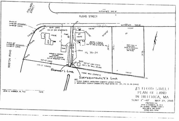
The Perotti parcel at 3 Floyd Street and the Krajewski parcel at 316 Boston Road had once been part of a larger tract of land owned by Henry Essex, from whom the deeds and descriptions for the properties at issue come. A three day trial was held before me, jury-waived. Mr. Perotti and the Krajewskis each called upon their respective surveyors to testify as to how they surveyed the parcels based on descriptions contained in prior deeds and recorded plans. As more fully set forth below, based on the descriptions contained in the deeds for the properties, the testimony of the respective surveyors, and my assessment of the credibility, weight and inferences to be drawn from the evidence and the usual interpretive hierarchies employed to resolve inconsistencies, I find and rule that the boundary line at issue is as set forth in the survey performed by John Hammer on behalf of Mr. Perotti (the Hammer survey, attached to this Decision as Exhibit 1).
Facts and Analysis
The location of a disputed boundary line is a question of fact to be determined on all the evidence. Hurlbert Rogers Machinery Co. v. Boston & Maine Railroad, 235 Mass. 402 , 403 (1920). When deed construction is a part of that analysis, the law provides:
a hierarchy of priorities for interpreting descriptions in a deed. Descriptions that refer to monuments control over those that use courses and distances; descriptions that refer to courses and distances control over those that use area; and descriptions by area seldom are a controlling factor. Moreover, when abutter calls are used to describe property, the land of an adjoining property owner is considered to be a monument.
Paull v. Kelly, 62 Mass. App. Ct. 673 , 680 (2004) (internal citations omitted). Monuments, when verifiable, are thus the most significant evidence to be considered. Other principles also provide guidance. In general, property descriptions in prior deeds in a deed chain take precedence over inconsistent descriptions of the same land in later deeds, for the simple reason that a grantor cannot convey more than he possesses. [Note 1] See C.M. Brown, et al., Browns Boundary Control and Legal Principles (4th Ed.), John Wiley & Sons, Inc., New York (1995) (hereafter, Browns Boundary Control) § 2.6 at 32 (No surveyor or court has authority to alter or modify a boundary line once it is created. It can only be interpreted from the evidence of where that boundary is located), § 3.1 at 33 ([O]ne who grants title to property to a second person can grant no more interest than what is owned). In situations of doubt or ambiguity, however, subsequent conduct (most notably, lines of occupation) and later deeds are sometimes helpful in resolving that uncertainty since property owners descriptions and actions may be indicative of the originally intended grant, and those of their successors may mirror and follow them. See generally Bacon v. Onset Bay Grove Assn., 241 Mass. 417 , 423 (1922). Here, however, there was no testimony from either the current or prior owners regarding their subsequent conduct. Both sides relied solely on the evidence presented by their respective surveyors who each interpreted the deeds at issue. Ambiguity in deeds of abutting properties, however, does not preclude the courts ability to determine the location of a boundary line in dispute, placing it wherever the totality of the evidence indicates. Indeed, the law recognizes that descriptions sometimes varyoften due to differences in measurements taken at different times by different persons (who may or may not have been professional surveyors) using different tools or methodsand allows the court, after considering all the evidence, to resolve them. See Paull, 62 Mass. App. Ct. at 682 n. 16; Browns Boundary Control § 2.6 at 32.
The Perotti and Krajewski parcels had once been part of a larger tract of land owned by Harry Essex extending from the Boston-Maine Railroad tracks to the east to Boston Road to the west. Beginning in the 1920s and continuing through the 1950s, Mr. Essex divided his property and conveyed those lots. In 1923, 13 Floyd Street, abutting the railroad tracks, was the first property conveyed from the Essex land. 11 Floyd Street came next in 1948. The Perotti parcel, 3 Floyd Street, was sold in 1950. Two other properties to the east of the Perotti parcel, 7 and 9 Floyd Street, were sold in 1951 and 1953, respectively. The last parcel conveyed from the original property was 316 Boston Road where Mr. Essex lived and which is now owned by the Krajewskis.
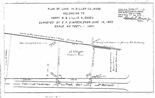
Since it was first conveyed in 1950, the description for the Perotti parcel has been consistent from deed to deed: northerly by Floyd Street 150 feet; Easterly by land now or formerly of Harry W. Essex 172.20 feet; Southerly by a stone wall by land now or formerly of the heirs of Edward Murphy 163 feet, more or less; Westerly by land of Harry Essex 149.75 feet, more or less. The deeds also incorporate by reference a Plan of Land in Billerica, Mass., Belonging to Harry W. and Lillie S. Essex, E. P. Simpson, O.E., June 14, 1950, recorded at the Middlesex North District Registry of Deeds at Book 78, Plan 24 (the 1950 Essex plan, attached to this Decision as Exhibit 2).
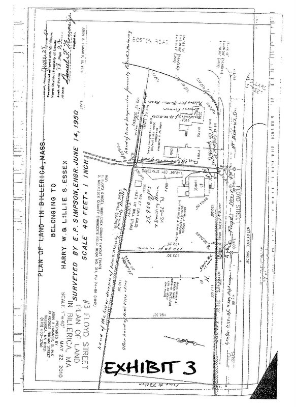
The different approaches taken by each sides surveyor in placing the common boundary line is at the center of this dispute. Mr. Hammer began his survey by locating the stone wall that forms the boundary of Floyd Street, and which is shown on the 1950 Essex plan and another 1950 plan of Floyd Street by the Middlesex County Commissioners. The location of that stone wall along Floyd Street also marks the Perotti parcels northern boundary. Mr. Hammer then located another stone wall marking Perottis southern boundary, which still exists on the ground. From the 1950 Essex plan, Mr. Hammer knew the angle of Perottis eastern boundary line extending from the northern stone wall on Floyd Street is 90 degrees. Since these two stone walls to the north and south do not run parallel, but instead converge toward each other in the direction of Boston Road, there can be only one point where a 90 degree line between these two walls measures 172.20 feet. That 172.20 foot line forms the eastern boundary of the Perotti parcel. Once Mr. Hammer located the northeast and southeast corners of the Perotti parcel, he then followed the rest of the description in the Perotti deeds. He measured 150 feet of frontage along Floyd Street thus arriving at the northwest corner of the Perotti parcel. Then, referring to the 1950 Essex plan, he measured an angle of 94.04 degrees and extended a line 149.75 feet to the south, thus locating the Perotti parcels southwest corner. Mr. Hammers survey produced a southern boundary measuring 162.23 feet, very close to the measurement in the Perotti deeds of 163 feet, more or less. When Mr. Hammers survey is overlaid on top of the 1950 Essex plan, his boundaries almost perfectly correspond. See Trial Chalk A, attached as Exhibit 3 (depicting Hammer survey overlaid on the 1950 Essex plan).
The Krajewskis surveyor, Antoni Szerszunowicz, took a different approach to his survey. He located the northeast corner of the Perotti lot by adding up the various frontages for all the parcels along Floyd Street that had been conveyed from Mr. Essexs tract of land. But by locating the Perotti parcel along Floyd Street in this way, his measurement for Perottis eastern boundary, going north to south between the two stone walls, is off. Where Mr. Hammer found the 172.20 foot distance referred to in the Perotti deeds, when Mr. Szerszunowicz measured Perottis eastern boundary, he got a distance of 175 feet. Mr. Szerszunowicz attributed this discrepancy to the irregularity of the stone walls, despite the fact that when the Perotti parcel was laid out and depicted on the 1950 Essex plan, the stone walls shown on that plan proceeded along regular, straight lines, which Mr. Hammer was able to replicate in his own survey. Furthermore, at trial, Mr. Szerszunowicz conceded that if he moved his eastern boundary for the Perotti parcel further west so that his line intersected with the southern stone wall at 172.20 feet, the distance between the two lines would be approximately 8 feet, which is the amount in dispute on Perottis western boundary.
In contrast to the precise measurements describing the Perotti parcel, the initial deeds that begin the Krajewski chain contain poor descriptions and essentially reflect Mr. Essexs intent to convey whatever land he had left after selling his earlier parcels. Thus the property description in the Perotti chain of deeds takes precedence over the imprecise descriptions in the Krajewskis chain because the Perotti parcel was conveyed first, and thus Mr. Essex could not have conveyed more to the Krajewskis predecessor-in-title than what he had. See Browns Boundary Control, supra at p. 2-3. The deed that begins the Krajewski chain contains a verbatim description of the entire Essex tract of land along Floyd Street taken from the deed given to Mr. Essex when he obtained the property in 1919:
A certain lot of land with the buildings thereon situated on the Easterly side of the road leading from Lowell to Billerica Centre and on the Southerly side of the road leading from said Billerica and Lowell Road to the Town of Tewksbury; Beginning at a stone bound on the Easterly line of said Billerica and Lowell Road at a corner of the wall at land conveyed by Mary Donovan to Kate T. Bradley by deed dated June 27, 1900; thence Easterly by the wall by said land conveyed as aforesaid to the Boston and Maine Railroad location; Southerly by said railroad location to land now or formerly of Daniel Floyd; thence Easterly crossing said Railroad and by said Floyd land to land now or of T. Foster Farmer; thence Northerly by said Farmer land to said road leading to Tewksbury; thence Westerly by said Tewksbury road to said Billerica and Lowell Road; thence southerly by said Billerica and Lowell Road to the bound first mentioned and the point of beginning.
Deed from Harry W. Essex to Geneve E. Ingersell and Harry W. Essex, as joint tenants with right of survivorship, April 28, 1961 (Trial Ex. 4(c)). After repeating this full description of property, most of which Mr. Essex no longer owned, Mr. Essex added the following [t]here is excepted from the above described premises so much there-of as has been conveyed by deeds of record. Id. Mr. Hammer interpreted this deed as Mr. Essex essentially saying that Im giving you this poorly described piece of property subject to unnamed conveyances that have already taken place that are senior to your rights. (TT 1-40).
The next deed in the Krajewski chain repeats the same description of the property. But the following deed in the Krajewski chain from 1972 supplies measurements for the Krajewski parcel for the first time. It provides no measurement for the frontage along Floyd Street, but it does describe the eastern boundary (bordering the Perotti parcel) as 149.75 feet and the southern boundary, by land now or formerly of Sampson [318 Boston Road], one hundred seventy-five (175) feet, more or less. Mr. Szerszunowicz relied on that 175 foot southern measurement for his own survey. Mr. Szerszunowicz measured the Krajewski parcels southern boundary from Boston Road as 175.12 feet, [Note 2] thereby shifting the common boundary line between the Perotti and Krajewski parcels further east, closer to Mr. Perottis house. By contrast, Mr. Hammers survey measured the Krajewski parcels southern boundary at 167.43 feet.
What accounts for the significant difference between these two measurements for the Krajewskis southern boundary line?
I find and conclude that Mr. Hammer provided a credible explanation for why the 175 foot measurement in the 1972 deed differs to such an extent from the measurement he obtained. Quite simply, he explained, it is more likely than not that no such measurement was ever taken. No plan has ever been recorded for the Krajewski parcel showing its precise dimensions. Rather, it is more likely that whoever drafted the 1972 deed looked at measurements in the deeds of abutting properties and simply copied those figures into the 1972 deed. By copying the 175 foot measurement from prior deeds that describe the boundaries for 318 Boston Road (located to the south of the Krajewski parcel) the drafter of the 1972 deed assumed that these two abutting properties shared a common boundary that was the same length. But, in fact, they do not. This can be demonstrated by considering the 1950 Essex plan, which shows that the common boundary line for the Perotti and Krajewski parcels falls to the west of a town brook shown on the plan, part of which has since been covered over and submerged and thus is no longer visible on the ground. But, when the Hammer survey is overlaid on top of the 1950 Essex plan, his common boundary line falls on the correct side of the town brook as it existed in 1950, at a point 167.43 feet from Boston Road. When Mr. Szerszunowiczs 175.12 foot measurement is overlaid on top of the 1950 plan, the common boundary line between the Perotti and Krajewski parcels plainly falls on the wrong side of the town brook. See Exhibit 2 (depicting locations of the Hammer common boundary line and the Szerszunowicz common boundary line in relation to the town brook as it existed on the ground in 1950). Although the 1950 Essex plan does not provide a measurement for the Krajewski parcels southern boundary, it is clear that it could not have been 175 feet since such a distance would have extended to the eastern side of the brook. Thus the common boundary between the Krajewski parcel and 318 Boston Road cannot be the same length.
Considering the totality of the evidence, I am persuaded that Mr. Hammers location of the common boundary line is the correct one. The descriptions and measurements contained the Perotti chain of deeds are consistent from the time the parcel was first conveyed, and since those deeds come before the Krajewski deeds, they take precedence over the relatively poor and inconsistent descriptions found in the Krajewski chain. Mr. Szerszunowiczs survey of the Perotti parcel yields measurements that are inconsistent with the description found in the Perotti deeds. Most notably, his eastern boundary, which he measured as 175 feet, differs significantly from the 172.20 feet called for in the deed. Mr. Hammers measurements corresponded to those found in the Perotti deeds and when his survey is compared with the 1950 Essex plan, his boundaries align with those in that plan and his placement of the common boundary at issue falls on the correct side of the town brook as shown on the 1950 Essex plan.
Conclusion
For the foregoing reasons, I find and rule that the boundary line between the Perotti and Krajewski parcels is the line shown on the Hammer survey measuring 149.75 feet. See Exhibit 1.
Judgment shall enter accordingly.
SO ORDERED.
Exhibit 1

Exhibit 2

Exhibit 3

FOOTNOTES
[Note 1] An exception to this is when the grantor later acquires the additional property and the doctrine of estoppel by deed comes into play. Estoppel by deed occurs when a grantor conveys property by deed which, unknown to the grantee, the grantor does not own at the time of the conveyance, but which the grantor later acquires. In such a case, the grantor (and anyone claiming under him) is estopped from asserting against the grantee a claim of title to the property conveyed. Zayka v. Giambro, 32 Mass. App. Ct. 748 , 751 (1992) (internal citations omitted). There are also instances where the totality of the evidence shows that the earlier description was erroneous and the later ones correct.
[Note 2] Not to be confused with Mr. Szerszunowiczs 175 foot measurement for Perottis eastern boundary.