Where it appeared that an owner of a tract of land conveyed the northerly portion thereof "together with all rights of way to" a street abutting the tract on the south without specifying the location or boundaries of the granted way, that many years later he conveyed the middle portion of the tract by a deed granting also a right of way in a specifically described location across the southerly portion of the tract to the street and excepting and reserving "a right of way described in" his deed of the northerly portion, and that simultaneously with the later conveyance he conveyed the southerly portion of the tract by a deed excepting and reserving a right of way in the location described in the deed of the middle portion and also "a right of way described in" his deed of the northerly portion, a conclusion was warranted that the right of way created in favor of the northerly portion over the southerly portion had the same location as the right of way created in favor of the middle portion over the southerly portion. [157-158]
Use of a certain strip of a parcel of land for a period of six years by the owner of nearby land having an undefined right of way by grant to a street over the parcel, apparently acquiesced in by the owner of the parcel during that period, sufficed to fix the strip used as the location of the right of way. [158]
Nonuse for many years of a right of way by the owner of the dominant estate, coupled with his failure to clear the right of way of its natural cover of trees and brush, did not establish abandonment of the right of way. [159]
Proof merely of the presence on a right of way of trees and brush and a dump during a period of thirty-three years in which the owner of the dominant estate did not use the right of way did not establish an adverse use by the owner of the servient estate which extinguished the right of way. [159-160]
BILL IN EQUITY, filed in the Superior Court on April 18, 1952.
Page 154
The suit was heard by Paquet, J., on a master's report. The defendant appealed from the final decree.
John P. Schlosstein, for the defendant.
Jacob J. Butler & Joseph Swirsky, for the plaintiffs, submitted a brief.
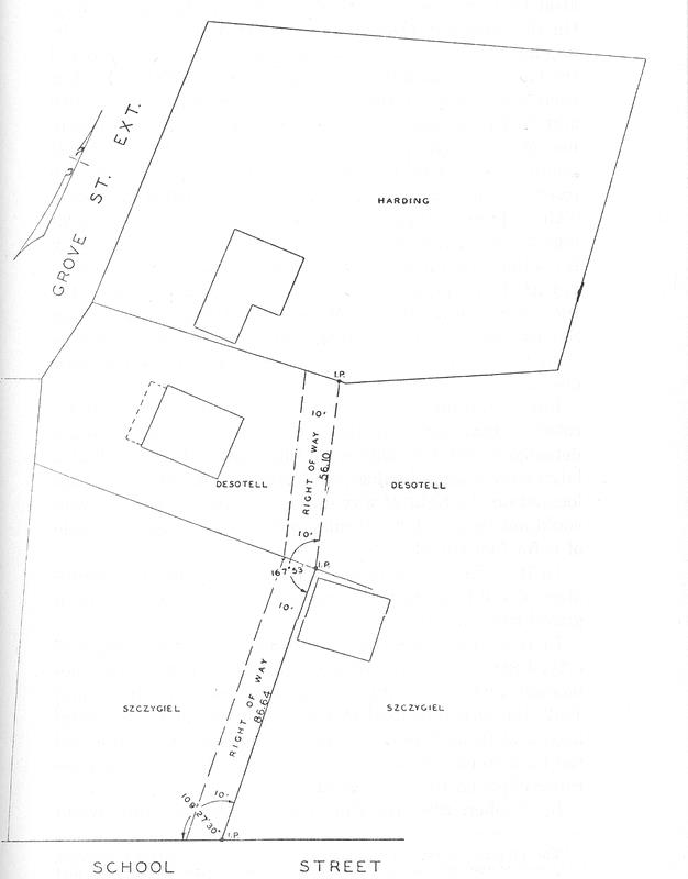
SPALDING, J. Fred G. and Lily I. Harding are the owners of the lot appearing on the upper or north portion of the plan reproduced on page 155. Anna E. Desotell is the owner of the lot to the south of and contiguous to the Hardings' property. South of Desotell's lot is the property of Katarzyna Szczygiel, the defendant. The Hardings and Desotell brought this suit to have the defendant enjoined from obstructing the way on her land shown on the plan over which the plaintiffs assert a right of passage.
A master to whom the case was referred found these facts. On February 11, 1884, title to the properties now owned by the plaintiffs and the defendant was in one Taft. Each deed in the chain of title of the Hardings conveyed the property "together with all rights of way to School Street and other rights appurtenant" to said premises, but the location and boundaries of the right of way were not specified in any of the deeds.
However, the deed, dated December 11, 1909, from the original grantor, Taft, in the chain of title of the property owned by Desotell described the easement granted as follows: "Also hereby granting and conveying a right of way at all times and for all necessary purposes 10 feet in width and about 86 feet in length across other land of the grantor adjoining said described premises and lying next southerly therefrom. Said right of way running across the easterly portion of said adjoining premises and being bounded by a line drawn parallel to the easterly line of said adjoining premises and 10 feet distant westerly therefrom. Excepting and reserving a right of way described in deed of Stephen Taft to [the first predecessor in title of the plaintiffs Harding]." [Note p154-1] Each conveyance of the Desotell property thereafter
Page 155
Page 156
contained an identical description of the right of way. On the same day (December 11, 1909) that Taft made the original conveyance in Desotell's chain of title he conveyed the land now owned by the defendant to one Wallace. [Note p156-1] The deed excepted and reserved a "right of way 10 feet in width and 86 feet in length measured westerly from the easterly line of said premises as described in the deed to [the first grantee of the land owned by Desotell]." There was also reserved and excepted "a right of way described in deed of Taft to [the first grantee of the land owned by the Hardings]." The same description of the land and rights of way is contained in all subsequent deeds, including the deed conveying the property to the defendant on May 21, 1937. On the same date the defendant gave a mortgage to the Palmer Savings Bank. This mortgage contained the same description, reservations and exceptions set forth in all the prior deeds.
For a continuous period from 1905 to 1938 there were located on that portion of the right of way running across the defendant's land as shown on the plan trees, including a large elm, a large boulder, and bushes. A dump was also located on the right of way during this period, and the way could not be used for vehicular traffic, and no use was made of it for foot travel.
In 1938 the defendant cleared the area within the boundaries of the right of way over her land, and constructed a gravel road thereon.
In 1939 one Meyer, the then owner of the Desotell property, began to use the road several times a week, the defendant making no objection to this use. In November, 1942, the Desotells used this road to bring in their belongings, and from that time until September, 1952, subjected the road to continuous use. After 1952 this use ceased because objected to by the defendant.
In October, 1946, the Hardings used the road to move in
Page 157
their furniture, and continued to use the road thereafter until 1952, although less frequently than the Desotells.
The master concluded that "the right of way over the defendant's property mentioned in the defendant's and Desotell's chain of title as being eighty-six feet long and ten feet wide is correctly located on the plan." He found, however, that the Hardings had failed to sustain their burden of proving a right of way over the Desotell property. [Note p157-1]
An interlocutory decree was entered confirming the master's report and overruling the defendant's exceptions. The final decree adjudged that the defendant's land was subject to a right of way, as located on the plan, in favor of the Hardings and Desotell; the decree also permanently enjoined the defendant from obstructing or interfering with its use by the plaintiffs. The defendant's counterclaim setting up extinguishment of the easement by adverse possession was dismissed. The defendant appealed.
There was no error.
1. The defendant's first contention is that there were no facts found by the master which support the conclusion that the Hardings have a right of way in the strip shown on the plan. It is not contended that the location of the easement in favor of the Desotell land was not adequately described in the deed given by Taft, the original grantor, and was not correctly located on the plan.
It is true that the deed given by Taft in 1884 to the predecessors in title of the Hardings does not fix the location of the right of way granted to them. However, the deeds given by Taft in 1909 to what is now the Desotell property and what is now the defendant's property, after setting out the location of the right of way shown on the plan, both except and reserve the right of way created in favor of the Harding property and refer to the deed of that property given by the grantor in 1884. It should not be readily inferred that the grantor's intent was to subject the servient estate to two separate and distinct rights of way. We think that the master's
Page 158
conclusion that the right of way created in favor of the Harding property has the same location as that created in favor of the Desotell property was correct.
Even if evidence of the intent of the original grantor and grantee is insufficient, the location of a right of way may be fixed or changed by the parties. "An undefined right of way by grant may be located by the parties, and a way once located may be changed by them." Brooks v. Quinn, 266 Mass. 132, 137. See Anderson v. DeVries, 326 Mass. 127, 132. From October, 1946, when the Hardings took possession of their property, until 1952, when the defendant objected to the use of the roadway by the Hardings and the Desotells, the Hardings used the described right of way. The defendant apparently acquiesced in this use during this six year period. These acts of the parties were sufficient to fix the location of the right of way, or to change the location if the original grantor and grantee ever intended to establish a different location.
The finding of the master that the Hardings failed to sustain their burden of proving the location of their right of way over the Desotell property is of no consequence. We are concerned here only with the location of the right of way over the defendant's property.
2. The defendant next contends that the easements in favor of the Hardings and the Desotells have been extinguished by abandonment. We could dispose of this contention on the ground that abandonment, an affirmative defence, has not been pleaded; the point is obviously an after-thought. But, passing to the merits, it has been said that whether there is an abandonment is a question of intention. Les v. Alibozek, 269 Mass. 153, 158. See Alvord v. Bicknell, 280 Mass. 567, 571; Dyer v. Siano, 298 Mass. 537, 541-542; Restatement: Property, Section 504, comment c. In Willard v. Stone, 253 Mass. 555, 561-562, it was said that the "abandonment of an easement, whether acquired by grant or prescription, cannot be found unless it clearly appears that such abandonment was intended by the owner." See Dyer v. Sanford, 9 Met. 395, 402. The defendant concedes, as she
Page 159
must, that nonuse of itself, no matter how long continued, will not work an abandonment. Arnold v. Stevens, 24 Pick. 106, 112-113. Delconte v. Salloum, 336 Mass. 184, 188. Restatement: Property, Section 504, comment d. See Am. Law of Property, Sections 8.96, 8.97. Nevertheless, all that is relied on to show abandonment is nonuse for many years by the Hardings and the Desotells and their predecessors, coupled with their failure to clear the right of way of its natural cover of trees and brush. This falls far short of establishing abandonment.
3. Another defence is that the easements have been extinguished by adverse use. Acts of a servient tenant incompatible with the existence of an easement, extending over the twenty year period required for prescription, will extinguish an easement. New England Home for Deaf Mutes v. Leader Filling Stations Corp. 276 Mass. 153. As we said in the recent case of Delconte v. Salloum, 336 Mass. 184, 189, quoting from Section 8.102 of Am. Law of Property, "A use of the servient tenement, to have the effect of extinguishing an easement in it . . . must be wrongful . . .. To be wrongful it must be of such a nature as to give rise to a cause of action in favor of the owner of the easement. To do this it must either interfere with a use under the easement or have such an appearance of permanency as to create a risk of the development of doubt as to the continued existence of the easement." And see Patterson v. Simonds, 324 Mass. 344, 352, and cases cited therein; Restatement: Property, Section 506, comment b.
Here it has been found that the right of way was not used from 1905 to 1938, and that it was covered with trees and brush during that time. However, the presence of these objects cannot be said to constitute an adverse use by the servient tenant, in the absence of a showing that the servient tenant planted the trees and brush on the right of way. There was no such showing here. The master did find that there was a dump located on the right of way during this period. But it did not appear that the servient tenant established this dump or that he used it. Nor did it appear
Page 160
that the dumping interfered with the use of the right of way or had such an appearance of permanence as to create a risk of doubt as to the continued existence of the easement. The finding of the master that a dump existed on the right of way from 1905 to 1938, without more, does not satisfy the defendant's burden of proving that the easement was extinguished by adverse use. Patterson v. Simonds, 324 Mass. 344, 352. Bartlett v. Roosevelt, Inc. 258 Mass. 494, 497.
Interlocutory decree affirmed.
Final decree affirmed with costs of this appeal.
FOOTNOTES
[Note p154-1] The property shown on the plan as belonging to Anna E. Desotell lying east of the right of way is not in this chain of title, having been first acquired by Desotell's immediate grantor in 1941.
[Note p156-1] The property shown on the plan as belonging to Katarzyna Szczygiel lying east of the right of way is not in this chain of title, having been first acquired by her in 1940.
[Note p157-1] With this finding we are not concerned. Nothing touching it was embodied in the decree.