Allegations in a petition in equity that a strip of land was "laid out" in a recorded development plan "as a public way," and that the petitioners had "considered it an open and public right of way" and with others had "used . . . [the strip] as shown on said . . . [plan] as a public way . . . for more than 20 years," did not constitute an allegation that the strip was a public way within G. L. c. 231, Section 30; and failure of the respondent to file a special demand for proof did not constitute an admission that the strip was a public way. [100-101]
After an issue whether a strip of land was a public way had been fully tried on evidence in a proceeding in equity, the point that it had been admitted under G. L. c. 231, Section 30, in the proceeding that the strip was a public way could not be raised for the first time in this court on appeal. [101]
A finding that an easement to a street over a strip of land from land abutting the strip had been acquired by prescription was not warranted by evidence merely that the owner of the abutting land had used the strip with the permission of the owner thereof to some extent to truck gravel out, that such use terminated after seven years when the owner of the abutting land built a fence along the common boundary, that the fence stood there for more than twenty-four years, during which the owner of the abutting land made no use of the strip, and that after the fence was removed the owner of the abutting land for some five years had used the strip from time to time as a short cut to the street but never by vehicle. [101-102]
An easement by necessity over a strip of land to a street was not implied in favor of land abutting the strip where it appeared that the abutting land had direct access to and egress from a public way other than such street and that the chain of title to the abutting land was different from that of the strip. [102]
The owner of lots on the north and south sides of a strip of land, whose chain of title extended back to a developer of a large tract through mesne conveyances all referring to a plan recorded by the developer and showing the strip as a part of a named street terminating at the easterly boundary of the tract, was not estopped, as against the owners
Page 97
of land abutting the tract on the east and in a different chain of title, to deny that the strip was "an easement, right of way and/or thoroughfare for public use" because of such references in the deeds in his chain of title or because the deed to the abutters indicated that a portion of the westerly line of the land conveyed was the easterly end of the named street. [102-103]
The mere recording of a development plan of land by the owner and his subsequent conveyance of lots shown thereon by descriptions which referred to the plan did not constitute a dedication to the public use of the streets shown on the plan. [104]
In a proceeding in equity in which this court decided that the petitioners had no easement or other right in a strip of land abutting their land, they had no standing to question the respondent's asserted title to the strip or to have deeds thereof from her to a straw and from the straw back to her declared null and void. [104-105]
In a proceeding for declaratory relief, this court ordered entry of a final decree declaring that the petitioners had no easement or other rights in a certain strip of land and permanently enjoining them from entering upon the strip, but declined to pass upon the respondent's title to the strip since the record did not indicate that all persons or parties entitled to be heard on that question were before the court. [105]
PETITION IN EQUITY filed in the Probate Court for the county of Berkshire on July 5, 1967.
The case was heard by Hanlon, J.
Philip H. Grandchamp for the respondent.
John A. Barry (Arnold L. Rose with him) for the petitioners.
QUIRICO, J. This is an appeal by the respondent from the final decree of the Probate Court in a suit in equity under G. L. c. 231A. By its decree the court declared that a parcel of land which the respondent claims to own had been dedicated to public use and was therefore subject to the petitioners' right to use it as a means of ingress and egress to and from their abutting land.
The judge made a report of the material facts found by him, and the evidence is reported. G. L. c. 215, Sections 11, 12. All questions of law, fact and discretion are open for our decision. We may find facts for ourselves in addition to those found by the judge and, if satisfied that he was plainly wrong in making certain findings, we may find facts contrary to such findings made by him. Lowell Bar Assn. v. Loeb,
Page 98
315 Mass. 176, 178. Shattuck v. Wood Memorial Home, Inc. 319 Mass. 444, 445. Gordon v. O'Brien, 320 Mass. 739, 740. White v. White, 322 Mass. 30, 31. Sulmonetti v. Hayes, 347 Mass. 390, 391.
The facts, most of which were found by the trial judge, are as follows. In 1913, J. W. Wilbur (Wilbur) owned a large tract of land in Pittsfield. He caused a plan to be
Page 99
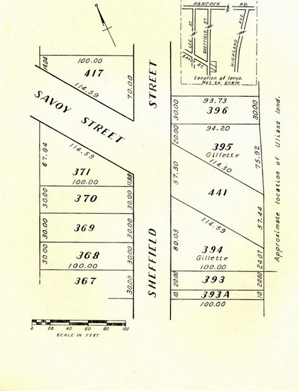
prepared and recorded in the registry of deeds showing a layout of a proposed development of the entire tract into 440 numbered lots on eight proposed streets. It showed a number of lots extending from the easterly line of Sheffield Street (the most easterly of the four north-south streets) to the easterly line of Wilbur's tract. It also showed Savoy Street (the most northerly of the four east-west streets) crossing Sheffield Street and continuing between two lots to the easterly line of Wilbur's tract. This case involves a controversy over the rights of the parties in and to that dead-end portion of Savoy Street located east of Sheffield Street, and shown on the plan as bounded on its southerly side by lot No. 394 and on its northerly side by lot No. 395, both of which are owned by the respondent. A sketch of the area involved accompanies this opinion.
The respondent became the owner of lot No. 394 in 1948 [Note 1] and of lot No. 395 in 1960. Her chain of title extends back to Wilbur through a series of mesne conveyances. All those conveyances which are in evidence describe the lots by their number on the Wilbur plan of 1913, and they identify the plan by its name, date and book of recording.
In 1958 the respondent executed a deed to a straw, purporting thereby to convey to him the portion of Savoy Street at issue here. In the deed she stated that "[m]y title to the above described parcel is based upon the adverse possession and usage of the same by myself and my predecessors in title for a period exceeding twenty years." On the same date the straw conveyed the parcel back to her by a deed which omitted the reference to adverse possession. As a result of the recording of these two deeds the board of assessors of the city of Pittsfield designated the area conveyed as lot No. 441 on their map of land in that area, and they have assessed the lot to the respondent each year from 1959 to date. The portion of Savoy Street at issue in this case will therefore be referred to herein as lot No. 441.
On April 27, 1962, the petitioners purchased two contiguous
Page 100
parcels of land by a single deed from one Kolodrubski and his wife. [Note 2] The deed describes the first parcel conveyed as having a westerly line 752 feet long. That line is in part the common boundary between the petitioners' land and the respondent's lots Nos. 394 and 395, and the disputed lot No. 441. The length of the common boundary with lot No. 441 is about fifty feet. The petitioners' land on its east side presently fronts on Highland Avenue, a public way, for a distance of sixty feet. This provides them with access to and egress from all of their property without going over any part of lot No. 441, or any part of the original Wilbur tract.
The portion of Savoy Street now known as lot No. 441 has never been laid out or established as a public way under G. L. c. 82. It has never been improved or constructed by the city or anyone else for use as a way. The city has never done or performed any work or made any improvements thereon. There are no water, sewer or other services or utilities installed thereon or thereunder.
Certain other facts of limited application to specific issues will be stated when those issues are discussed.
The petitioners base their claim of right to use lot No. 441 for access to and from their property on several grounds. We shall consider each ground separately.
1. The petitioners contend that they must prevail because they have alleged in their bill that lot No. 441 is a public way, and the respondent, while denying the allegation, made no "special demand for its proof" as required by G. L. c. 231, Section 30. [Note 3] Their allegations in this regard are: (a) that "Savoy Street is laid out in said . . . [development plan of Wilbur] as a public way, road and/or thoroughfare"; (b) that "They have considered it an open and
Page 101
public right of way or thoroughfare"; and (c) that they and others "used Savoy Street in its entirety, as shown on said map . . . [of Wilbur] as a public way, street or thoroughfare for more than 20 years." These allegations taken singly or collectively do not constitute an allegation that lot No. 441 is a public way within the meaning of G. L. c. 231, Section 30. On these allegations the respondent's denial without a special demand for their proof does not constitute an admission that the place in question is a public way. In any event, this point was not raised during the trial at which much evidence was presented by both sides on this very issue whether the place was a public way. It cannot be raised for the first time in this court. Even if the petitioners' allegations were sufficient to entitle them to the benefit of the statute, we would say that the issue having been fully tried, the case is an appropriate one for the allowance of an amendment to the respondent's answer to include the special demand for proof required by the statute. See Carson v. Brady, 329 Mass. 36, 41.
2. The petitioners contend that they have acquired an easement over lot No. 441 by prescription. Their predecessors in title, the Kolodrubskis, owned the parcel which abutted on lot No. 441 from 1931 until they conveyed it to the petitioners in 1962. [Note 4] They used lot No. 441 to some extent in trucking gravel out from their land. However, such use was with the permission of Wilbur, and not adverse. That use terminated by 1938 when Kolodrubski built a fence to contain cattle and thus sealed his common boundary with lot No. 441. That fence continued to an indefinite date after the Kolodrubskis conveyed the property to the petitioners in 1962. Neither they nor the petitioners made any use of lot No. 441 while the fence was standing. After the fence was removed the petitioners and their son used lot No. 441 from time to time as a short cut
Page 102
from their property to Sheffield Street. The use was irregular, and it was never by vehicle. These facts do not constitute the required open, notorious and adverse use for twenty years over the land of another to ripen into an easement by prescription. See G. L. c. 187, Section 2; Tucker v. Poch, 321 Mass. 321, 323, and cases cited; Restatement: Property, Sections 457, 458.
3. The petitioners contend that they have acquired an easement over lot No. 441 by necessity. This contention is without merit for two reasons. First, there exists no necessity sufficient to give rise to the implication of any such easement. The petitioners have access to and egress from their property directly onto Highland Avenue which is a public way. [Note 5] While it is settled that the necessity which may give rise to the implication of an easement need not be an absolute physical necessity, yet it must be a reasonable necessity. Mt. Holyoke Realty Corp. v. Holyoke Realty Corp. 284 Mass. 101, 105, and cases cited. Supraner v. Citizens Sav. Bank, 303 Mass. 460, 464. In this case there is no reasonable necessity for implying any easement in favor of the petitioners. Second, easements because of necessity can be implied only for the benefit of or against parties to a particular conveyance and their successors in title, and not for the benefit of or against strangers to the chain of title. Restatement: Property, Sections 474-476.
4. The petitioners contend that the respondent is estopped to deny that lot No. 441 is "an easement, right of way and/or thoroughfare for public use" because all of the deeds in the respondent's chain of title, starting with the developer Wilbur, refer to Savoy Street and to Wilbur's recorded plan showing that street. It is a well settled rule that a grantor who conveys land by a description incorporating therein a recorded plan on which a street is shown, or by a description showing the land to be bounded on a street or way, is thereafter estopped, as are his successors in title, from denying the
Page 103
existence of an easement of travel over that street or way for the benefit of the grantee and his successors in title. Downey v. H. P. Hood & Sons, 203 Mass. 4, 10. Stevens v. Young, 233 Mass. 304, 309. Goldstein v. Beal, 317 Mass. 750, 755. Casella v. Sneierson, 325 Mass. 85, 89. It is equally clear that only the grantee in such a deed and his successors in title to the granted property are entitled to the benefit of such estoppel; and that they are entitled to use the easement resulting from such estoppel only in connection with the land conveyed by the deed giving rise to the estoppel, and for no other property. The right of way created by the estoppel is appurtenant to the land conveyed, and it is not an easement in gross. Murphy v. Mart Realty of Brockton, Inc. 348 Mass. 675, 678-679. The petitioners are not grantees of Wilbur, by deeds referring to his recorded plan or to Savoy Street. Thus, the case of Walker v. E. William & Merrill C. Nutting, Inc. 302 Mass. 535, relied on by the petitioners, does not apply. The fact that the Kolodrubskis in their deed to the petitioners used a description indicating that for a distance of about fifty feet the westerly line of the land they conveyed bounded on the easterly end of Savoy Street, now lot No. 441, does not estop the respondent from denying that the petitioners have any easements on said lot No. 441.
5. The petitioners contend that by recording his development plan in 1913 Wilbur established Savoy Street as "a right of way or thoroughfare or private way for public use." The trial judge appears to have decided the case in their favor on this ground. [Note 6] We disagree with this contention and with the judge's conclusions thereon. The portion of Savoy Street in controversy was never laid out or established
Page 104
as a public way, and there is no evidence that it was ever "treated as such by the [c]ity." It has not been possible to establish a public way by dedication since the passage of St. 1846, c. 203, Section 1, now incorporated in G. L. c. 84, Section 23. [Note 7] Hayden v. Stone, 112 Mass. 346, 348. Rouse v. Somerville, 130 Mass. 361, 365. Dakin v. Somerville, 262 Mass. 514, 515. Longley v. Worcester, 304 Mass. 580, 585. Loriol v. Keene, 343 Mass. 358, 360-361. Since the primary purpose of this statute is to eliminate municipal liability for defects in streets which have not been formally laid out and established in the statutory manner, it may still be argued that there can be ways or streets dedicated to public use, even though the municipality is not liable for defects therein. See Oliver v. Worcester, 102 Mass. 489, 495-496; Longley v. Worcester, supra, at 587; Loriol v. Keene, supra, at 360. Under such an argument the petitioners would have the burden of proving that the portion of Savoy Street in controversy was "open and dedicated to the public use." G. L. c. 84, Section 23. They must prove "the intent of the owner which must be made manifest by his unequivocal declarations or acts to appropriate his land to a public use and to surrender its control to the public." Longley v. Worcester, supra, at 587. The only evidence cited by the petitioners as the basis for this claim is Wilbur's recording of his development plan and his subsequent conveyance of lots by descriptions which referred to the plan. That is not enough to constitute a dedication to public use of the streets shown on the plan. Hayden v. Stone, 112 Mass. 346, 349, and cases cited. Loriol v. Keene, supra, at 360-361.
6. The petitioners request a declaration that the respondent has no title to lot No. 441, and that the deeds from her to the straw and from the straw back to her are null and void. By reason of our decision that the petitioners have no easement or other right over the land in question it follows that
Page 105
they have no standing to question the respondent's title thereto or to have the deeds declared null and void. The respondent, being in possession of that land, has the right to continue in possession as against any person except the true owner, or a person having a superior right to possession. The petitioners are not such persons. Barnstable v. Thacher, 3 Met. 239, 243. Sweetland v. Stetson, 115 Mass. 49. Nickerson v. Thacher, 146 Mass. 609. New England Box Co. v. C & R Constr. Co. 313 Mass. 696, 707.
By her answer the respondent seeks a declaration that she is the owner of the land in question, and she asks that the petitioners be enjoined from entering upon it. Even though the petitioners have no standing to question the respondent's title, it does not follow that we can declare in this proceeding that the respondent is the owner of the land. There is nothing in the record to indicate that we have before us all persons or parties entitled to be heard on that issue. [Note 8]
The final decree entered by the Probate Court on March 4, 1968, is reversed. A new decree is to be entered (a) declaring that the petitioners have no easement or other rights in or to the portion of Savoy Street which is now identified as lot No. 441 on the maps of the board of assessors of the city of Pittsfield, and (b) permanently enjoining the petitioners from entering upon said lot No. 441. The respondent is to have costs of appeal.
So ordered.
FOOTNOTES
[Note 1] From 1948 to 1954 the respondent owned lot No. 394 with her husband; and she became the sole owner of it in 1954.
[Note 2] The deed gives the total area of the two parcels as about thirteen acres; but it excepts therefrom several portions thereof previously conveyed, and a portion being retained by the grantors. The portions excepted do not affect this case.
[Note 3] This statute provides in part that "If it is alleged in any civil action or proceeding that . . . a place is a public way, such allegation shall be taken as admitted unless the party controverting it files in court . . . special demand for its proof."
[Note 4] There is no evidence to show that Wilbur owned any part of the land now owned by the petitioners when he recorded his development plan in 1913, or to show that the petitioners hold their land or any other rights or easements under any grant or conveyance from Wilbur or his successors in title.
[Note 5] The petitioners' present frontage on Highland Avenue is sixty feet, having been reduced thereto by their conveyance between 1962 and 1966 of five parcels fronting on that street.
[Note 6] Subparagraph 5 of the final decree of March 4, 1968, says that "[s]aid disputed parcel was dedicated for public use by J. W. Wilbur in recording said plan . . ., and remains open to the public as a means of ingress and egress to and from any and all land abutting thereon." The last paragraph of the judge's "Amended Report of Material Facts" entered April 16, 1966, says that ". . . the disputed area . . . was designated as a public street by the owner, J. W. Wilbur, in 1913, and was treated as such by the City of Pittsfield, though never officially accepted or improved by the city."
[Note 7] "A way opened and dedicated to the public use, which has not become a public way, shall not, except as provided in the two following sections, be chargeable upon a town as a highway or town way unless laid out and established in the manner prescribed by statute."
[Note 8] The owners of other lots shown on Wilbur's recorded plan, or the owners of some of such lots, may be necessary parties on this issue; but we make no present decision thereon.